
A Western Planner in FEMA’s court - Learning about the community rating system
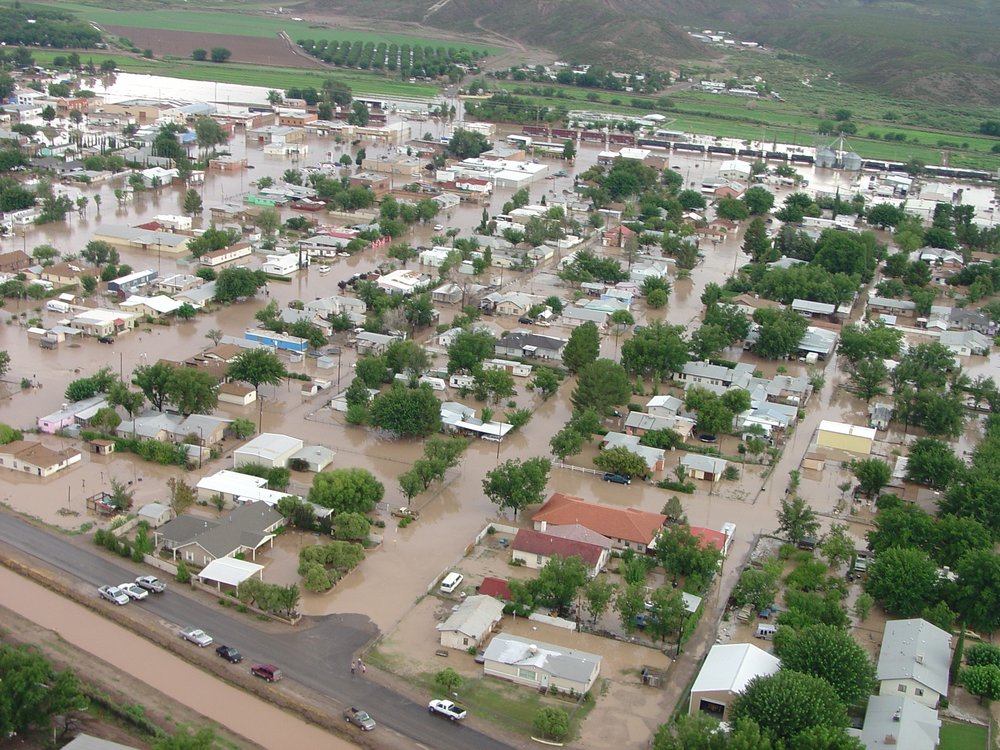
THE SOUTHERN NEW MEXICO COMMUNITY OF HATCH INUNDATED BY FLOODWATERS IN 2006. PHOTO COURTESY OF NEW MEXICO FLOODPLAIN MANAGERS ASSOCIATION.
by Brad Stebleton,CFM, Bernalillo, New Mexico
Being a planner in one of the small communities or rural counties in the Western Planner region usually means working with a small staff and wearing many hats. Along the way, it means learning a lot about professions and responsibilities that aren’t traditionally considered to be part of the planning field. The phrase “not in my job description” really has no meaning in this setting since your job duties often expand to fill unmet needs, whatever those might be.
When I arrived in Sandoval County in 1998 the first major task I had to take on concerned flood insurance, or more specifically the county’s nonparticipation in the National Flood Insurance Program (NFIP). The county had passed the required Flood Damage Prevention Ordinance, but had not completed the necessary paperwork with the federal government (FEMA) to be accepted into the program. As a result, I had a flood of phone calls from residents throughout this very large county (over 3,700 square miles) complaining that they weren’t able to buy flood insurance. Entrance into the NFIP is a requirement in order for property owners in a community to buy federally backed flood insurance. Flood insurance is not included in a standard homeowner’s insurance policy.
I shortly found myself appearing in front of five regulation-wary county commissioners, asking them to adopt the necessary resolution to join the NFIP. Luckily, this group of long-term county residents understood the devastating impacts of floods, which can appear with little or no warning. Proper insurance is often the only thing standing between a family and financial ruin.
So I added floodplain management to the other myriad responsibilities that go along with being a planner in a very small department. In the process, I gained a new perspective on development review, considering proposed development in its natural context with a greater emphasis on the threats to life and property from potential flooding. Due to a subsequent change in state law, I added the credential of Certified Floodplain Manager (CFM) to my resume, an act that required the passage of a not-so-easy written examination.
Fast forward 17 years and our county received a Community Assistance Visit (CAV) from representatives of our state government and our FEMA regional office in Denton, Texas. A CAV, conducted every 2-3 years, is basically an audit of the community’s floodplain management program. Over the period of several days, the visitors look at all of the permit records for development in and around floodplains, including subdivisions and drainage plans, to make certain that your program is in compliance with your local flood damage prevention ordinance and with NFIP requirements. Onsite inspections of recent development in close proximity to flood-prone areas are part of the program. As was the case with prior visits, the county was found to be running our program in conformance with all applicable requirements. However, this time things were different.
The specialists believed that our county was now ready to join the Community Rating System (CRS). This program, which now includes just over 1,000 municipalities, townships, and counties from throughout all 50 states, operates in a similar manner to the Insurance Service Office (ISO) rating system for fire departments. The floodplain management program for each member community is evaluated according to a rather long list of criteria. Membership is voluntary, but by joining there is a potential to lower the flood insurance premiums paid by a community’s property owners. As with ISO for fire departments, communities are assigned a class number from 1-10. The lower the number; the better the rating and the larger the discount in flood insurance premiums.
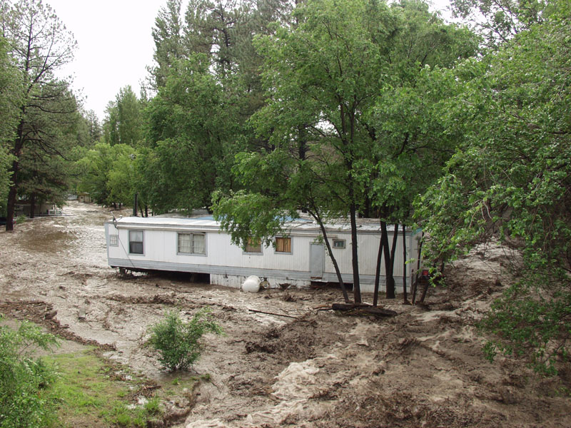
THE POWER OF FLASH FLOODING IN THE MOUNTAIN TOWN OF RUIDOSO, NEW MEXICO IN 2008. PHOTO COURTESY OF NEW MEXICO FLOODPLAIN MANAGERS ASSOCIATION.
This program is sufficiently complex that training and education are necessary, particularly for communities who are joining for the first time. Fortunately, FEMA does offer such training and I and another county employee headed east in April 2016 to the National Emergency Training Center (NETC) in Maryland. Established in 1979, NETC shares its 107-acre campus with the National Fire Academy. If approved to attend a class at the NETC, FEMA picks up most of the cost which is good news, particularly for small communities and rural counties with limited budgets.
The NETC course was more intense than college courses with information coming very quickly and in large chunks. Instruction is conducted in the military technical school model with 50 minutes of class time followed by a ten-minute break. It was four very densely packed eight hour days. Fortunately for attendees, the instructors largely avoided speaking in acronyms, an unexpected pleasure for all of us.
The items for which a community can receive CRS credit are divided into distinct parts known as Activities and Elements. While some of those units involved more esoteric items such as flood insurance and flood hazard disclosure and bureaucratic subjects such as the proper use of certain forms and paperwork, it didn’t take long to see how other parts of this program intersect with the best planning practices.
A great deal of credit is given to communities that protect areas within their floodplains as permanent public open space. Not only are the number of residences and businesses lying within harm’s way reduced, but the resulting reduction of impervious surfaces (i.e. concrete and rooftops) helps the floodplain to function more naturally and reduces the volume and velocity of flood waters when such events do happen. This can also be a “win-win” for a community in the intermountain west as such open space areas can be used for recreational purposes for much of the year when they are dry. Examples of these kinds of facilities abound throughout the region and include soccer fields, playgrounds, and golf courses.
The good news for purposes of the CRS is that communities can claim this credit even if the open space is owned by another entity such as a flood control or irrigation district. While the program also gives credit to communities that acquire and remove existing structures from the floodplain, this is much more expensive than preventing such structures from being built in the first place.
A great deal of emphasis and CRS credit is given for the use of Geographic Information Systems (GIS) in administering a community’s floodplain management program. Credit is assigned for having an accurate inventory of the acreage of your community that lies within a floodplain and the number of existing homes and businesses in that area. It is hard to imagine that you could effectively administer a floodplain management program or do effective land use planning in the 21st century without such an inventory and GIS makes this task relatively simple to accomplish.
Still, more credit is given in the program for…….planning! Not the type of planning that we are used to in our profession but a specific type of plan known in the FEMA lexicon as a Hazard Mitigation Plan. This plan is designed such that a community is prepared for and takes steps to minimize or avoid the detrimental effects of natural disasters, which includes other events besides flooding, such as earthquakes and wildfires. As land use planners we should, as a matter of course, take these issues into consideration as our communities develop. Besides causing planners to focus our attention on issues we might otherwise overlook, the Hazard Mitigation planning process is a good vehicle to break down the “silo formation” that often occurs in local governments. By engaging in this process, you will find yourself working together and coordinating with other agencies in your community such as emergency services, law enforcement, and public works.
One of the most common ways that communities can earn CRS credit is by adopting a “freeboard” requirement. The minimum requirements of the NFIP stipulate that a participating community must require that structures in floodplain areas be constructed at or above base flood elevation. The base flood elevation is the predicted water surface elevation resulting from a 100-year flood (a flood that has a 1 percent chance of occurring in any given year). Obviously, if the finished floor grade of a house is right at the 100-year flood level, is it really that safe? Does anyone seriously believe that the floodwater is going to stop right there and not go an inch higher? Anyone who has observed the damage from a flash flood in the southwest realizes that the power of water often comes down to a game of inches. In fact, six inches of fast flowing water can knock an adult off of his or her feet.
Adopting a “freeboard” requirement means that your community requires structures in a floodplain to be elevated to some level above the base flood elevation, most commonly one foot. Our county adopted a one-foot freeboard requirement back in 2008 that was met with no resistance. Perhaps it was a case of good timing since we had some nasty flash flooding not long before this requirement was adopted, reminding residents of the value of an extra cushion in the ordinance.
After returning with all of this newly acquired knowledge, the real fun begins. The county must prepare all the documentation necessary to claim the credit under the CRS program. Then we must invite a team of insurance specialists to come out and evaluate our documentation to determine how much credit we receive under the program and accordingly how much money our residents save on their flood insurance premiums. This experience has at various times been compared to a root canal or a colonoscopy depending on who you talk to, but it is a necessary evil. If the property owners in your community can save money by you taking the time to document things you are doing anyway, it is well worth the effort. It is not unlike finding coupons for items that were already on your grocery list.
If you find yourself at the intersection of planning and floodplain management, attend a course at the Emergency Management Institute if you possibly can. And don’t wait 20 years to do so like I did. Even if your community doesn’t join the CRS program there are lots of opportunities to learn interesting and useful things at EMI and to interact with allied professionals. Such time is never wasted.
Too often we, as planners, spend a lot of time talking with and learning from each other but too little time interacting with those in other professions. Working in a small planning department like mine (two planners) this is less of a problem, but we can all make more of an effort to learn from those outside of our profession. I am always pleased to see allied professionals at The Western Planner conferences. Besides, with the long list of communities in our region that have been impacted by flooding, including Fort Collins (CO), Rapid City (SD), Ruidoso (NM), and Reno (NV), to name a few, learning more about this topic can only help all of us as planners.
Brad Stebleton is a senior planner for Sandoval County, NM. He is a Certified Floodplain Manager. He currently serves as secretary on the board of Western Planning Resources and is the chair of The Western Planner Editorial Board.
Published in the December 2016/January 2017 Issue