
Wasatch Front residents find a better way to grow

The photo above illustrates mixed use. Photo provided by the Wasatch Front Regional Council.
If projections hold true, the population of Salt Lake, Davis, Weber, and Utah counties in Utah will grow from 2.2 million people today to 3.7 million by 2040—a 68 percent increase in the next 30 years.
by Val John Halford, AICP
There is little doubt that residents along the Wasatch Front enjoy a very high quality of life. They enjoy access to beautiful natural areas that are located within short traveling distances. Friendly communities with abundant amenities are populated with folks noted for their high sense of civic duty and volunteerism. Despite the recent downturn in the nation’s economy, Utah has fared well, with a much lower rate of unemployment than that experienced in other states. Utah’s highly educated work force is a draw for many companies. As the “Crossroads of the West,” the state enjoys a unique geographic location that provides an edge in economic competitiveness with other Western states.
However, much of what Utah’s citizens take for granted could change in the coming years with the impact of unprecedented growth. Utah is the fourth fastest growing state in the nation. If projections hold true, the population of Salt Lake, Davis, Weber, and Utah counties will grow from 2.2 million people today to 3.7 million by 2040—a 68 percent increase in the next 30 years.
At the same time, Utah itself will increase from 2.7 million people to 5.2 million—nearly double. It should come as no surprise that the state has the lowest median age at 28.5, compared with the national average of 36.4 years. About 62 percent of projected growth is homegrown and the balance, 38 percent, will come from net-in-migration. Accompanying this anticipated growth is the need to plan and plan today or the consequences will adversely affect tomorrow’s quality of life.
As population increases, so does travel demand. The growth in vehicle miles traveled may decrease in the coming years in response to raising gasoline prices. However, current projections show a near doubling of miles driven between now and the next 30 years —from 49 million miles driven per day in 2009 to over 90 million by 2040. Vehicles are becoming much cleaner and more hybrid and electric cars will be on the road in the future. Given the geography of the Wasatch Front, air pollution will continue to be an important health concern.
Without changing Utah’s “business as usual” approach to land planning, the increase in population over the next three decades will consume approximately 300 additional square miles. Most of the prime agricultural land, located in the western portions of Weber, Davis, and Utah counties, will disappear. Of particular concern in the coming years is housing affordability with the price of land increasing as the supply begins to grow short. Unfortunately, the Wasatch Front is headed toward an unsustainable future that will not support the lifestyles residents currently enjoy.
Traditionally, local community general plans were used by regional transportation planning agencies to allocate projected population and job growth throughout their multi-county jurisdiction. New transportation facilities were designated to meet this growth. This somewhat reactionary planning effort had several drawbacks, including the assignment of new roadways and transit facilities based on local general plans, many of which had not been updated in years. The Wasatch Front Regional Council’s (WFRC) mission is to develop transportation plans that cost-effectively meet the mobility needs of existing and future residents, while preserving the quality of life throughout the region. Unfortunately, billions of dollars of regional transportation improvements, planned over the next several decades, may not be necessarily supported by local land use decisions. A more proactive and “visionary” approach was needed to ensure the type of growth choices and transportation investments selected work together to create the future desired.
About the Photos
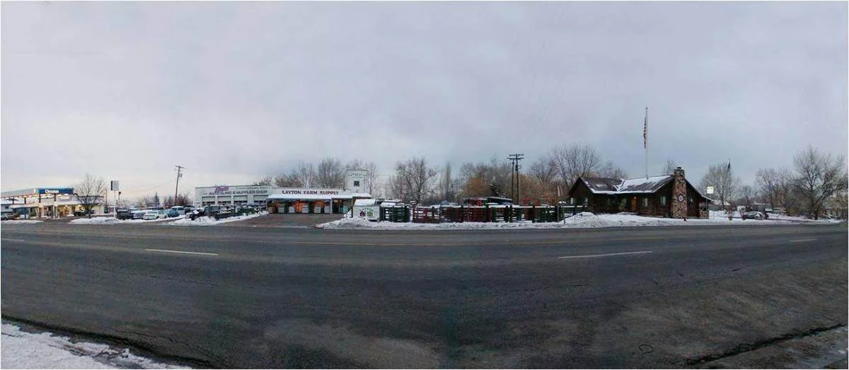
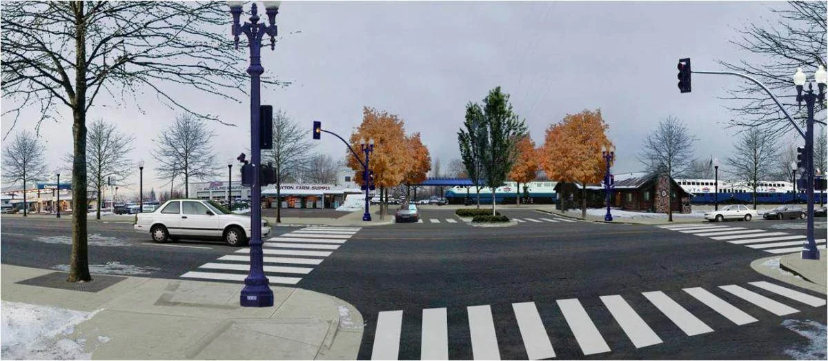
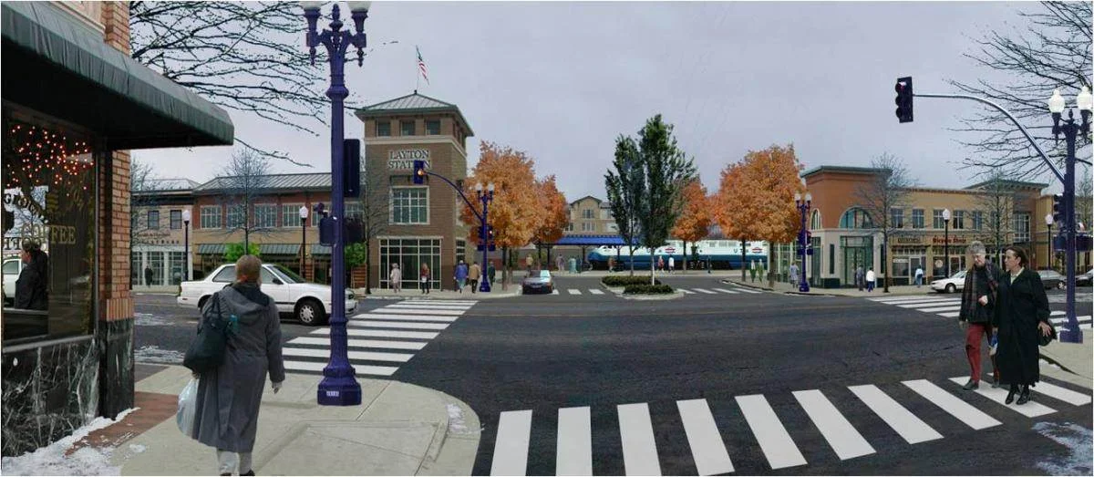
The three photo representations are examples of how certain development scenarios could look. During the process, the public was invited to review scenarios on how the four-county Wasatch Front Region could develop. The first scenario was based on existing city plans and showed how the region would grow if elected officials adopted a “business as usual” approach. The other three scenarios were different combinations of highway, transit, and land use patterns. Photos provided by the Wasatch Front Regional Council.
Wasatch Choice for 2040
Click Image to open to full size.
Beginning in 2004, Utah’s largest two metropolitan planning organizations (MPO), the WFRC and Mountainland Association of Governments (MAG), collaborated in the creation of a land use and transportation vision map and a series of growth principles known as Wasatch Choices 2040. The WFRC, MAG, Envision Utah, Utah Department of Transportation, and Utah Transit Authority jointly funded this innovative regional planning effort. As part process, citizens and special interest groups from 60 cities and towns in four counties indicated their preferences for various development patterns, housing, employment, public transportation, and major roadways in one process. In effect, residents were asked to answer two questions: What is the future we want to create? What growth patterns and transportation investments would help create that future?
Next, the public was invited to a second round of five open houses in July and August 2005 to review scenarios on how the four-county Wasatch Front Region could develop. Participants indicated which elements of each scenario they supported. The first scenario was based on existing city plans and showed how the region would grow if elected officials adopted a “business as usual” approach. The other three scenarios were different combinations of highway, transit, and land use patterns. A stakeholder committee, representing 57 public and private organizations, helped to refine the regional vision and the growth principles. Eighty-two individuals, including 21 elected officials, participated. An independent poll was used to help provide input into this important planning process.
In early 2005, more than 1,000 residents of Weber, Davis, Salt Lake, and Utah counties attended 13 community workshops and created 120 regional maps. Through Wasatch Choices 2040, residents along the Wasatch Front helped shape the future of roads, transit, and other modes of transportation in their communities. Residents also examined the relationship of the transportation system to neighborhoods, jobs, farms, and open lands.
Many of the communities in the region did not have the planning staff or funding to undertake long-range visioning. The Wasatch Choices 2040 process provided each community, at no cost, access to meaningful long-range scenarios built from grassroots input tested with the MPOs’ transportation modeling capability and Envision Utah’s land-use modeling system. By involving these communities in a unified visioning process, a dialogue ensued between them on how decisions within jurisdictional boundaries affected both neighboring jurisdictions and the region as a whole.
WFRC unanimously adopted the growth principles in late 2005, and in late 2006, the final report was released. More than 2,000 copies were distributed to elected officials, developers, environmentalists, affordable housing advocates, bankers and others. In 2007, an educational forum was held to promote the growth principles and implementation strategies. More than 200 professionals participated from the public and private sectors. Workshop participants applied the principles to five case studies.
Beginning in 2007, Wasatch Choices 2040 was refined further, focusing on a series of urban centers and corridors that would provide residents who want to live close to work, walk, or bike to shop, and have both great transit and road access the opportunity to do so. Rechristened as the Wasatch Choice for 2040, the vision map accommodates anticipated growth in various metropolitan, urban, town, and transit-station centers, along with mixed-use corridors, which offer a wide-range of retail, office, and residential uses.
The Wasatch Choice for 2040 helped further define and coordinate freeways, rail lines, rapid bus ways, and transit stations while safeguarding natural resources, such as working farms, parks, and trails. Identified centers throughout the region would be connected with a robust transportation system, especially transit, allowing growth to be absorbed in higher density areas. This improved vision, adopted by the WFRC in May 2010, was used to allocate socio-economic numbers for the development and modeling of the 2011—2040 Regional Transportation Plan adopted by the WFRC in May 2011.

This photo illustrates open space. Photo provided by the Wasatch Front Regional Council.
Benefits of Implementation
Wasatch Choice for 2040 points the way forward for the region to focus growth in a variety of activity and urban centers, all of which will be connected with viable transportation modes and choices. While these centers coordinate with today’s transportation system, tomorrow’s new transportation investments will be planned to serve these activity centers, areas of growth, and the region’s special districts—such as airports, regional hospitals, commercial shopping districts, parks and open space, and universities. Implementing the Wasatch Choice for 2040 will provide residents with more choices for safe and affordable housing, support healthier and more vibrant communities, save billions in tax dollars, conserve beautiful natural areas, and make travel more convenient.
When modeled and analyzed, the regional vision resulted in 18 percent less traffic congestion. Overall mobility should increase, thus helping to promote Wasatch Front’s economic viability and Utah’s overall competitiveness with other Western states. Businesses will profit through improved worker productivity and enhanced movement of goods and services. Utah’s ability to recruit and retain jobs and highly skilled workers will be enhanced. By growing in a more efficient fashion, billions of dollars can be saved in infrastructure costs—roads, utility lines, water and sewage treatment plants, etc. Significant transportation costs, an estimated $4.5 billion reduction over the next 20 years, will be realized.
The vision draws on reliable market research and public input showing that changing demographics and consumer housing preferences, increasing land and energy costs, and a growing desire to trade commute time for family and recreation time drive demand for living in town centers. Wasatch Choice for 2040 would create active “walkable” neighborhoods near new transit centers and would result in 12 percent more transit use.
The vision provides more choices for how present and future generations will live, work, play, and travel. In short, the vision gives people what they want: more variety in housing types, transportation modes, neighborhood demographics, and lifestyles.
In Salt Lake, Davis, Weber, and Utah counties, current general plans call for developing nearly 300 additional square miles of land by 2040. About 100-square miles of development will be agricultural land converted into residential use. Modeling results predict that Wasatch Choice for 2040 will consume approximately 23 fewer square miles of land by 2040 than the “business as usual” land planning.
Finally, the vision will result in the direct benefits of cleaner air and water and will help to identify and preserve viable farms, critical open space, and improved overall public health.
Summary
Given current growth projections, the Wasatch Front is headed toward an unsustainable future. Continuing past development patterns will adversely impact the overall quality of life. The way communities develop affects all aspects of lives, and if land use practices of the past few decades continue, the consequences will be severe. The Wasatch Front cannot sustain its current path, and Utah’s dramatic growth requires that planners make wise decisions. By implementing the Wasatch Choice for 2040 vision, Utah can accommodate growth, enjoy financial security, build healthy communities, and preserve the state’s stunning beauty.
Val John Halford has been with the Wasatch Front Regional Council for the past 16 years, helping guide four regional transportation plans from conception to adoption. He has worked for West Valley City and Salt Lake City under former Mayor Deedee Corradini. He currently teaches several courses in the Geography Department at both the University of Utah and the Salt Lake Community College.
Published in the February/March 2012 The Western Planner