
Federal Lands in the West: A few facts and figures
FIGURE 1: SOURCE: U.S. GEOLOGICAL SURVEY, NATIONAL MAP SMALL SCALE, FEDERAL LANDS OF THE UNITED STATES.
by Candace H. Stowell, AICP, Carson City, Nevada
Throughout America’s history, federal land laws have reflected two visions: keeping some lands in federal ownership while disposing of others. From the earliest days, there has been conflict between these two visions.1
The significant amount of federal lands in the West has been a source of conflict for decades. The opposition to federal lands (and federal regulations) has intensified during the last two years with conflicts in Southern Nevada and most recently in Southern Oregon. The Bureau of Land Management (BLM), which manages the majority of federal lands in the West, continues to face challenges to its authority to manage public lands. Since the federal lands conflict will likely continue for several more decades, it is helpful to remember why the West retains such a high percentage of federal lands and to provide updated figures on the amount and location of those federal lands.
Figure 1 displays the location of federal lands throughout the country. Today, almost 50 percent of the land in the Western states is federally owned. It’s common to see contradictory figures about federal lands in the West. Presidential candidate Donald Trump stated in a Jan. 28 editorial in theReno Gazette-Journal that the BLM owned more than 85 percent of the land in Nevada (the BLM manages 66.9 percent of the lands in Nevada). Nevada Assemblyman P.K. O’Neil stated in a March editorial in the Nevada Appeal that the federal government owned 76 percent of the land in Nevada (the federal government owns 84.9 percent of the land in Nevada). Unfortunately, it is difficult to nail down precise figures on the amount of federal land by agency and state. Each federal agency prepares their own annual reports, and some agencies do not provide any land acreage information on their website.

One reliable source for updated information on federal lands, although not definitive, is the Congressional Research Service (CRS). CRS has prepared many reports on federal lands and in its most recent report, CRS stated the amount of federal land in Western states varied from 84.9 percent in Nevada to 61.3 percent in Alaska and 3.9 percent in North Dakota.2 Unfortunately, the CRS figures are only based on lands owned by three agencies in the U.S. Department of the Interior (BLM, Fish and Wildlife Service, and National Park Service), the Forest Service in the U.S. Department of Agriculture, and the U.S. Department of Defense. The CRS figures do not include the Bureau of Reclamation (U.S. Department of the Interior), the Department of Energy, or other federal agencies.
Definitions
To understand the current status of federal lands in the West, it is useful to know some of the definitions related to the acquisition of federal properties:
- Public Domain Lands: Public domain lands include all lands that were originally acquired by the United States as it expanded westward, either by purchase or by treaty.
- Public Land States: These are the 30 states that originated from the public domain lands: Alabama, Alaska, Arizona, Arkansas, California, Colorado, Florida, Idaho, Illinois, Indiana, Iowa, Kansas, Louisiana, Michigan, Minnesota, Mississippi, Missouri, Montana, Nebraska, Nevada, New Mexico, North Dakota, Ohio, Oklahoma, Oregon, South Dakota, Utah, Washington, Wisconsin, and Wyoming.
- Public Lands: These are lands owned by the United States and managed by the BLM, as opposed to other federal agencies, such as the National Park Service (NPS).
- Federal Lands: These are any lands owned and maintained by the federal government.
Public Domain Acquisitions and Disposals
The westward expansion of the United States was made possible by many acquisitions such as the Louisiana Purchase from France in 1803 and the Treaty of Guadalupe Hidalgo of 1848, which allowed the U.S. to acquire land from Mexico in what are today portions of Arizona, Colorado, New Mexico, and all of Utah, Nevada, and California. As shown in Table 1, the largest acquisitions were the Louisiana Purchase of 1803 at 529,911,680 acres, the Mexican Cession of 1848 at 338,680,960 acres and the Alaska Purchase of 1867 at 378,242,560 acres.
According to the 2014 BLM Annual Report on Public Land Statistics, a total of 1,287,380,000 acres were disposed between 1781 and 2014. The disposals included the homestead allotments to encourage settlement of the West, as well as disposals to the states for land grant colleges and public schools, as shown in Table 2.
SOURCE: CONGRESSIONAL RESEARCH SERVICE REPORT R42346, DECEMBER 29, 2014. CRS INCLUDES LANDS OWNED BY THE USDOI BUREAU OF LAND MANAGEMENT, THE USDA FOREST SERVICE, THE USDOI US FISH AND WILDLIFE SERVICE, THE USDOI NATIONAL PARK SERVICE, AND THE U.S. DEPARTMENT OF DEFENSE, TABLES 1 AND 4.
Current Federal Land Holdings
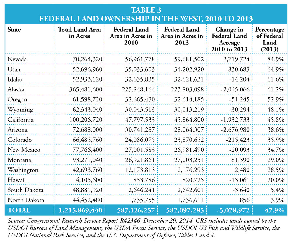
The amount of land owned by the federal government is certainly not static and can change in each state from year to year. Nevada has the highest percentage of federal land of the 50 states at 84.9 percent, but Alaska has the most federal land in absolute terms. According to CRS, the federal land in Alaska totals 223,803,098 acres compared to 59,681,502 acres in Nevada.
As shown in Table 3, the amount of federal lands in the West for five federal agencies has decreased by 5,028,972 acres between 2010 and 2013. For some individual states, however, the amount of federal acreage has increased since 2010. CRS reports that the amount of federal land acreage in Nevada increased by 2,719,724 acres, or 4.8 percent, since 2010. Again, these figures only reflect the land managed by the aforementioned federal agencies. Nevada provides a good example of this incomplete picture. If the CRS figures included the Bureau of Reclamation acreage (460,155 acres) and the Department of Energy acreage (878,876 acres in the Nevada Test Site), the total federal acreage in Nevada would increase from 59,681,502 to 61,020,532. This increases Nevada’s percentage of federal land from 84.9 percent to 86.8 percent.
The U.S. Department of the Interior, which is often referred to as the “Department of Everything Else,” includes most of the federal agencies that people in the West are familiar with: the BLM, the NPS, the U.S. Fish and Wildlife Service, and the Bureau of Reclamation. Figure 2 displays the location of Department of the Interior lands throughout the country.
The BLM, which was established in 1946 by merging the Grazing Service and the General Land Office, manages the most land of any federal agency. The BLM oversees 246,393,048 acres and almost all of the BLM land, or 99.99 percent, is located in the West (246,357,526 acres). As shown in Figure 3, Alaska, Nevada, Utah, and Wyoming contain the most BLM land in the West.
Two other significant agencies in the Department of the Interior include the U.S. Fish and Wildlife Service (USFWS) and NPS. USFWS was established in 1940 and manages more than 89,080,785 acres and 76,673,836 acres, or 86.1 percent of this acreage, is located in Alaska. NPS was established in 1916 (and is celebrating its centennial during 2016) and today manages 79,648,788 acres throughout the country, with 73,244,562 acres located in Western states, or 92 percent. The majority of NPS lands are located in Alaska.

FIGURE 2
The Forest Service, which is under the U.S. Department of Agriculture and includes approximately 35,000 employees, is the second largest federal landlord in the West. Created in 1905 with Gifford Pinchot as its first director, the Forest Service today manages 192,932,426 acres. Figure 4 depicts the location of national forests and national grasslands throughout the country. The amount of Forest Service lands in the West totals 166,819,068 acres, or 86.5 percent of the total Forest Service lands. The amount of USDA Forest Service land in the Western states is shown in Figure 5. The three states with the most Forest Service acreage include Alaska, California, and Idaho.

SOURCE: CONGRESSIONAL RESEARCH SERVICE, R42346, FEDERAL LAND OWNERSHIP: OVERVIEW AND DATA, DECEMBER 29, 2014. TABLE 2.
Federal Lands Data
In reviewing the current statistics on federal lands in the West, it is striking that better data on the amount and location of all federal lands is not available. As already noted, the CRS figures do not include land managed by the Bureau of Reclamation, a significant landlord in many Western states, or the Department of Energy (a significant landlord in Nevada). CRS estimates that total federal lands amount to approximately 640,000,000 acres but admits that the “total federal land in the United States is not definitively known.”3

FIGURE 4 USDA NATIONAL FORESTS AND GRASSLANDS SOURCE: 2015 BUDGET JUSTIFICATION, USDA FOREST SERVICE, MARCH 2014, APPENDIX K
Importance to Planners
Given the significance of federal lands in the West, it is important for planners to understand why federal lands are so dominant in many western states and to know what federal lands exist in their local jurisdiction. Several state legislatures are still lobbying their congressional representatives for significant federal lands transfers. The Nevada Legislature approved Senate Joint Resolution 1 in 2015 calling for the initial transfer of 7.2 million acres of federal lands. If the U.S. Congress ever approves the transfer of significant amounts of federal land to state and local governments in the future, management of these newly acquired federal lands will pose significant challenges for many communities.

SOURCE: PUBLIC LAND STATISTICS 2014, BUREAU OF LAND MANAGEMENT. HAWAII IS NOT INCLUDED SINCE THERE ARE NO BLM LANDS IN HAWAII.
Candace H. Stowell, AICP has been a professional urban planner for more than 25 years and has worked in the public and non-profit sectors and as a private consultant. She represents the Nevada APA Chapter on the Western Planning Resources Board and is the current Chair of the Western Planner Editorial Board.
Endnotes
- Congressional Research Service, R42346, Federal Land Ownership: Overview and Data, December 29, 2014.
- Congressional Research Service, R42346, Federal Land Ownership: Overview and Data, December 29, 2014.
- Congressional Research Service, R42346, Federal Land Ownership: Overview and Data, December 29, 2014, page 1, Footnote 1.
Published in the April/May 2016 Issue of The Western Planner