
The Value of Transportation Data for Economic Development
by Brian Carver
The interior West of the U.S. is often referred to as “fly-over” territory by the national media. It could as easily be called the country’s “drive-by” territory. Goods move from the major population centers and ports of the country’s coastlines to the many points of sale across the continent by truck and rail, setting many rural communities up as logistical hubs that must accommodate the infrastructure, services, and support industries necessary to keep the wheels turning. Additionally, many of the rural communities are origin points of freight in the form of food, fiber, and raw materials used in industry and the production of goods for domestic consumption and international export.
Fortunately, most of the more popular and strategically-valued routes are State-owned and operated, relieving rural communities of much of the burden of maintenance and improvement. However, as congestion grows and opportunities arise in new regions, freight traffic will always seek the fastest, most efficient route—often moving onto smaller local networks increasing the system liabilities for rural counties and communities.
Understanding the movement of these goods through communities is a key factor in planning for adequate infrastructure, as well as a good gauge for industries that could be targeted for expansion or capture through local development opportunities.
Bear River Association of Governments, the regional planning agency for the Northern Utah communities of Box Elder, Cache, and Rich Counties, recently commissioned a freight movement analysis in the hopes of clarifying local policy makers’ consideration of the commodities and products that have value to the local communities. IHS Markit was selected as the data vendor, and was asked to research external markets across the United States, Canada and Mexico. The most recent available dataset focused on 2019 but also included projections through 2045.
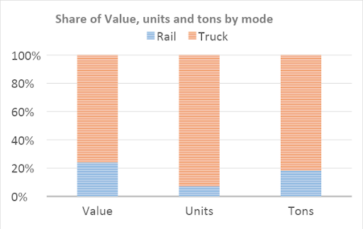
Not surprisingly, the greatest amount of freight is moved through the region by truck.
In the analysis of routes through Cache County and the Logan Utah Metropolitan Statistical Area—a small metropolitan planning area that straddles the Utah and Idaho borders—compelling images are provided that show the relative importance of a new north/south corridor built along 1000 West in Logan (on the left of the maps), compared to the traditional route through the downtown district (on the center-right of the maps). By measures of number of units, value, and tonnage, the new corridor has become the route-of-choice to shippers entering and leaving the community. This not only reduces traffic conflicts in the older downtown corridor, but highlights the economic value of the new corridor and adjacent land development patterns.

Mapped units

Mapped value

Mapped tons
As these routes connect out of the immediate community into the greater regional transportation network, including Interstate highways, communities are now able to see the value moving through each specific corridor. This can help direct investment of public and private funds to grow existing assets and access new opportunities through data-driven decision making.
About the Author
Brian Carver is the Community and Economic Development Director for the Bear River Association of Governments, located in Logan, Utah. Before his position in the Cache Valley, Brian worked for the State of Utah’s planning department. Brian is also currently represents Utah on the Western Planner Resources Board and is chairman of the planning commission for Hyrum City, Utah.