
The Crest of Montezuma

The Crest of Montezuma as seen from Placitas following a summer thunderstorm (Taken by Barb Belknap, Sandoval Signpost)
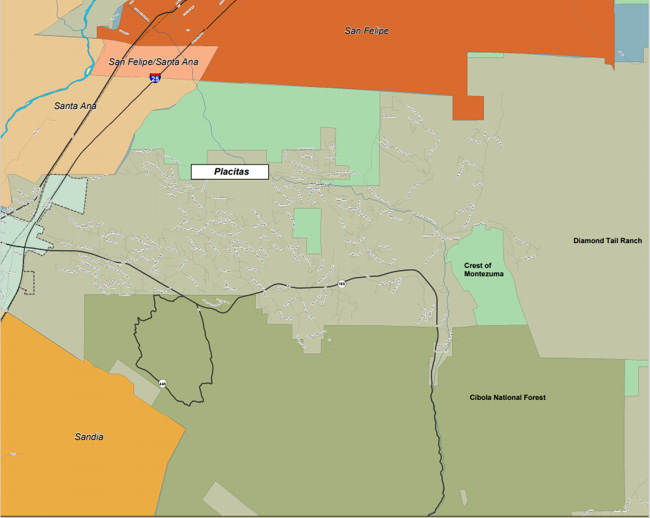
Just 15 miles north of Albuquerque in southeastern Sandoval County lies the community of Placitas. Once a tiny rural village, Placitas has grown very rapidly over the past few decades to become the largest unincorporated community in the County, with a population of more than 5,000 residents. Any visitor to the area can quickly discern the reasons behind this rapid growth. Placitas has easy access to Interstate 25 and urban conveniences, but features a semi-rural quality of life with large lots, abundant wildlife, quiet star-filled nights, and stunning mountain views.
One of those views is of the Crest of Montezuma, a dramatic promontory that forms a backdrop at the eastern edge of Placitas. Situated at the northern tip of the Sandia Mountains, the Crest adjoins the Cibola National Forest and its tens of thousands of acres of public lands, but the Crest itself had always been private property. Owned by the Apodaca family, the Crest was one of largest single parcels of private land in Placitas at just over 1,100 acres. Besides containing the famous promontory that gave the property its name, this land provides an important corridor for wildlife traversing the area and is thus ecologically sensitive. There are also believed to be some important archaeological sites on the land.
Given its location and the western affinity for housing with a view, it was perhaps inevitable that the Crest of Montezuma would attract offers from the development community. Sure enough, consultants representing a land development group paid a visit to our County office in the early 2000s to inquire about the necessary requirements for review and approval of a subdivision of this land. At about the same time, a neighbor spotted a gathering of people on the property, all of them looking at a large map that was spread out on the hood of a Lexus. There are few secrets in a small community like Placitas, and word of the possible development of the Crest of Montezuma spread like a western wildfire.
Area residents reached out to the Trust for Public Land (TPL), which has an office in Santa Fe (just 45 minutes from Placitas) and a well-deserved reputation for being able to broker deals to conserve sensitive properties. TPL representatives met with interested neighbors about options to conserve the land that would meet the needs of everyone concerned. Area residents were elated after TPL approached the Bureau of Land Management (BLM) and BLM representatives stated that they were interested in negotiating with the Apodacas to acquire and preserve the property. However, due to ponderous Federal purchasing requirements and red-tape, the BLM was not able to acquire the property in a timeframe suitable to the Apodacas. Through some deft negotiation TPL was able to line up Santo Domingo (now Kewa) Pueblo, a nearby Indian tribe, to be a “bridge” or “conservation” buyer, who would purchase and hold the property until the BLM was prepared to move forward. Santo Domingo closed the sale with the Apodacas in November 2003, thereby protecting this property from future development.
So, the sun came out, the birds started chirping and everyone lived happily ever after, right? Uh, no, not so fast! After all, this is the West and land deals in this region can get very complicated in a hurry. To start with, Santo Domingo was interested in trading with the BLM in order to acquire some ancestral lands close to their reservation. Those lands had to be identified and the necessary Federal procedures to trade those lands needed to be followed. Very shortly this trade grew in complexity as the Nature Conservancy and the New Mexico State Land Office got involved, since they were interested in trading other lands with the Pueblo and with BLM. Soon, what began as one transaction in Placitas became nine, involving properties in other areas of the County and the State, including lands in Sierra County in southern New Mexico, more than 150 miles away from the Crest. As you can imagine, all of this took time.
Other issues cropped up. BLM was not interested in obtaining the northerly 195 acres of the property, as it was cut off by a road and a Pipeline Station from the Crest itself and did not have the same ecological and archaeological value as the rest of the property. In order to be usable open space, the Crest needed a parking area for a trailhead. The most logical part of the property for this was a long and very narrow portion known as “the peninsula.” However, an obscure Federal regulation prohibited BLM from taking title to this portion of the property due to its unusual shape. To complicate matters further, the road that “the peninsula” fronted on was privately owned. The West is filled with woeful tales of public lands being isolated by private property, particularly when that property changes hands---nobody wanted that to happen here.
Enter Diamond Tail Ranch. Diamond Tail owns thousands of acres adjoining the Crest to the east, and ranch owner Joe Matthews had an acute interest in the future of the Crest and the associated land trades. Joe had a well-earned reputation as a diligent steward of his land, and he stepped up and offered to buy the 195 acres that the BLM was not interested in. The way Joe saw it, this additional acreage would provide an important buffer at the “front door” of his ranch. It was at this point that Sandoval County got involved in the project, as the private road adjoining “the peninsula” was owned by Diamond Tail and Joe offered to dedicate this roadway to the County in perpetuity if we would acquire “the peninsula” and create the future parking area. Several meetings were held between the various parties and all were agreeable to the Diamond Tail/Sandoval County proposals. It now looked like the whole project was headed toward a satisfactory conclusion.
Then we encountered another problem. During an onsite inspection of the area, several of us from the county government determined that “the peninsula” was a less than ideal candidate as a parking area after all. While the grades and lines of sight were quite good, the narrow configuration of the property made it difficult for longer vehicles, such as horse trailers, to turn around. Once again, Joe came up with a solution that kept the project going. Immediately to the south of “the peninsula” was another long narrow property that had longstanding issues with legal access. That owner was looking to sell and Joe agreed that Diamond Tail would buy this property and convey it to the County. The two properties combined contained sufficient width to make for a very nice parking area, and we were back in business.
Now that all the pieces were in place, it was time to get all of the parties together and finalize negotiations. This occurred at a meeting of the Santo Domingo Tribal Council, one of the very few times that outsiders have been invited to such a gathering, and a clear indication of how important this whole exchange was to the tribe. Not only did things go surprisingly smooth, but this gathering provided us visitors with a rare and special window into an indigenous culture. I found it to be a very powerful and moving experience. In accordance with Pueblo tradition, we all shared in a sumptuous feast following the conclusion of the meeting.
With the approval of the subdivision plat and road dedication by the Sandoval County Commission in December 2007, the last major piece was in place to allow the land exchange to occur. It was concluded shortly thereafter. While visiting his home district in 2009 Congressman (now U.S. Senator) Martin Heinrich joined a group of us on a hike to the top of the Crest. He was visibly moved by the panoramic views and pledged to work to ensure that this hard-won land would be protected.
Was that the end of the story? Not quite. While the Crest is now in public ownership and protected from private development, its future is not certain. The BLM has pledged to develop a management plan to protect wildlife habitat and allow for low-impact recreational uses. However, the agency is also in the middle of a very long process to revise its Resource Management Plan (RMP) for 9.5 million acres of its lands in north-central New Mexico (including the Crest). The ultimate outcome of this process is unknown. Many interested residents and groups in the area believe that transferring the Crest from the BLM to the adjacent National Forest will provide a higher and more predictable level of protection for the land. While members of New Mexico’s Congressional delegation seem to agree, getting the necessary legislation through Congress will be a heavy lift.


Views from the top of the Crest (Taken by Brad Stebleton)
In the meantime, the Crest is available for low-impact recreational uses. A citizens group in the area conducts annual hikes to educate residents about the property. There are no established trails yet, but hikers can bushwhack their way to the top. If you find yourself in the area and can make this strenuous journey, it will be well worth the effort. As you take in the amazing 360-degree views and enjoy the solitude (yes you will likely be alone), it is useful to contemplate how this important piece of land was protected. It took steadfast perseverance to overcome the numerous roadblocks that were encountered throughout the process. In many cases, overcoming these obstacles required “thinking outside the box” to come up with innovative solutions. And while the whole process had many twists and turns and involved a lot of different people, groups, and agencies, it all began with a grassroots effort by concerned and caring citizens. And it will only be through continuing citizen involvement that this land will be preserved for the long haul.

Hikers at the top of the Crest in July 2009 (Left to Right): State Representative Kathy McCoy, Placitas Resident Reid Bandeen, Sandoval County Planner Brad Stebleton, Sarah Cobb (US Senator Tom Udall’s Office), US Representative Martin Heinrich (D-NM), Placitas Residents Dan Dennison, Orin Safier, Mitch Johnson, and Bill Lenoir (Photo courtesy of the Sandoval Signpost)
Joe Matthews, the long-time owner of Diamond Tail Ranch, passed away in January 2020, just before the COVID-19 pandemic hit the United States.
Brad Stebleton is a senior planner for Sandoval County, NM. He is a Certified Floodplain Manager. He currently serves as secretary on the board of Western Planning Resources and is the chair of The Western Planner Editorial Board.